Skip to content
Four Rivers Explorer
  • Nature & Wonder
  • Off The Beaten Path
  • Abandoned
    • Abandoned Places
    • Lost Roads & Railroads
  • Old Towns & Villages
    • Old Towns & Villages
    • Postscripts
    • The Map Room
  • Terts & Quats
  • The Timeline
Menu Close
Toggle the button to expand or collapse the Menu
  • Nature & Wonder
  • Off The Beaten Path
  • Abandoned Places
    • Lost Roads & Railroads
  • Old Towns & Villages
    • Postscripts
    • The Map Room
  • Terts & Quats
  • The Timeline

Henry Co. TN

  1. Home>
  2. Blog>
  3. Henry Co. TN

Recent Posts

  • Tharpe, Tennessee
    Tharpe, Tennessee
    February 27, 2023/
    0 Comments
  • Blue Spring, Tennessee
    Blue Spring, Tennessee
    February 24, 2023/
    0 Comments
  • Kentucky Lake’s Stonehenge?
    Kentucky Lake’s Stonehenge?
    February 14, 2023/
    0 Comments
  • Old Hillman Ferry
    Old Hillman Ferry
    April 27, 2022/
    0 Comments
  • 1880 Graves County Atlas
    1880 Graves County Atlas
    April 26, 2022/
    0 Comments

Categories

  • Abandoned
  • Lost Roads & Railroads
  • Nature & Wonder
  • Off The Beaten Path
  • Old Towns & Villages
  • Our Favorite Places
  • Postscripts
  • Terts & Quats
  • The Map Room
Read more about the article Abandoned Paris Landing Bridges
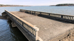
Several spans remain of the old Tennessee Highway 76 bridges before the creation of Kentucky Lake.

Abandoned Paris Landing Bridges

  • Post published:December 8, 2021
  • Post category:Abandoned
  • Post comments:0 Comments

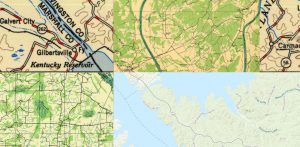
Kentucky Lake has plenty of unusual sights in the waters, such as the abandoned Danville Grain Elevator and Cemetery Island.  Another historical relic can be found at Paris Landing, sticking…

Continue ReadingAbandoned Paris Landing Bridges
Read more about the article Old Maps Overlaying Today’s Reveal Big Changes
A screen-grab showing four layers of maps centered on Grand Rivers, Kentucky.

Old Maps Overlaying Today’s Reveal Big Changes

  • Post published:September 11, 2018
  • Post category:Terts & Quats/The Map Room
  • Post comments:0 Comments

The United States Geological Survey has a great online mapping feature that is quite addicting and can suck you in for a while.

(more…)

Continue ReadingOld Maps Overlaying Today’s Reveal Big Changes

© 2006-2023 Four Rivers Explorer except content, images and photos credited on this site. All Rights Reserved.
We strive with our maximum capacity to properly attribute all our sources of images, photos and content.

By accessing this website, you agree to our Terms of Service. If you do not agree, please leave this site immediately.