Skip to content
Four Rivers Explorer
  • Nature & Wonder
  • Off The Beaten Path
  • Abandoned
    • Abandoned Places
    • Lost Roads & Railroads
  • Old Towns & Villages
    • Old Towns & Villages
    • Postscripts
    • The Map Room
  • Terts & Quats
  • The Timeline
Menu Close
Toggle the button to expand or collapse the Menu
  • Nature & Wonder
  • Off The Beaten Path
  • Abandoned Places
    • Lost Roads & Railroads
  • Old Towns & Villages
    • Postscripts
    • The Map Room
  • Terts & Quats
  • The Timeline

Briensburg KY

  1. Home>
  2. Blog>
  3. Briensburg KY

Recent Posts

  • Tharpe, Tennessee
    Tharpe, Tennessee
    February 27, 2023/
    0 Comments
  • Blue Spring, Tennessee
    Blue Spring, Tennessee
    February 24, 2023/
    0 Comments
  • Kentucky Lake’s Stonehenge?
    Kentucky Lake’s Stonehenge?
    February 14, 2023/
    0 Comments
  • Old Hillman Ferry
    Old Hillman Ferry
    April 27, 2022/
    0 Comments
  • 1880 Graves County Atlas
    1880 Graves County Atlas
    April 26, 2022/
    0 Comments

Categories

  • Abandoned
  • Lost Roads & Railroads
  • Nature & Wonder
  • Off The Beaten Path
  • Old Towns & Villages
  • Our Favorite Places
  • Postscripts
  • Terts & Quats
  • The Map Room
Read more about the article Detailed 1933 Map of Birmingham, KY
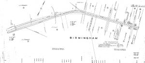
The map shows a drug store, livery, mill, and other stores in town.

Detailed 1933 Map of Birmingham, KY

  • Post published:September 8, 2020
  • Post category:Postscripts
  • Post comments:0 Comments

This map from the Kentucky Department of Highways shows land owners and businesses on the main road in Birmingham, Ky.

Continue ReadingDetailed 1933 Map of Birmingham, KY

© 2006-2023 Four Rivers Explorer except content, images and photos credited on this site. All Rights Reserved.
We strive with our maximum capacity to properly attribute all our sources of images, photos and content.

By accessing this website, you agree to our Terms of Service. If you do not agree, please leave this site immediately.