Linton, Kentucky has a similar tale of towns perched alongside rivers. The story is familiar – a promising shipping point in the early pioneer days only to be left behind by railroads and modern highways. Linton fits this scenario. But as with most of these old river communities, Linton has its share of unique storylines – from the irony of producing railroad ties to the legend of buried treasure.
A Promising Start
The earliest European settlers in the Linton area were the Westers, a family from North Carolina, who settled near Linton along the confluence of Dry Creek and the Cumberland River. The land surrounding the valley was terrible for homesteading, so early pioneers were drawn to the flat terrain surrounding Dry Creek. The Westers arrived sometime around 1798.
About the same time, an in-law of the Westers named Abel Olive arrived and established a landing on the Cumberland River called Olive’s Landing. He was an ambitious fellow and reportedly cut the first road out of Olive’s Landing through southern Trigg County. Based on our research, the landing didn’t take off until around 1820 – that was when steamboats began to regularly use it as a stopping point.
Buried Treasure
Just to the west of the Cumberland and Tennessee Rivers were lands belonging to the Chickasaw Peoples. In 1818, the US Government purchased a large chunk of land east of the Mississippi, south of the Ohio, and west of the Tennessee rivers from the Chickasaw.
The government and tribal leaders agreed to $300,000 paid in yearly installments of $20,000 for 15 years. This is equivalent to about $30 million in 2020 dollars.
A local legend says the Chickasaw hid the gold – presumably the first payment – at the Three Sisters Springs located just south of Olive’s Landing. The natural springs were hard to get to and featured a cave that would have been a good hiding place for such a treasure.
For decades after, many of the Chickasaw’s ancestors who knew about the legend would go to the springs and dig around, attempting to find the gold. One of the final trips came in 1964 when “Mouse” Futrell, a nearby resident and a friend named Glenn Cothran visited the springs. The US Army Corp of Engineers cleared the trees around the area of the springs to prepare for the creation of Lake Barkley.
With the trees and brush gone, the springs were easily accessible. The larger of the three springs had a hole about 30 inches across. Futrell said when he was a kid, he crawled through the hole which opened into a large cave.
When Lake Barkley was completed, the Three Sisters Springs and cave was completely submerged – ending the chances of anyone trying to find the buried treasure.
Olive's Landing to Shipsport to Linton
Around 1830, the name of Olive’s Landing changed to Shipsport. At that point, the landing began to be frequented by steamboats. The first general store formed in 1830 and the Stacker Iron Furnace arrived in 1845. The furnace brought employment and a period of prosperity for the community with new families moving into the area.
Like so many other furnaces in the region, the Stacker Iron Furnace didn’t last long and ceased operations in 1856. The 11,000 acres of land belonging to the Stacker company was purchased a couple years later. The purchaser and other individuals plotted the town of Linton in 1858 on seven acres and offered lots for sale. Linton became incorporated April 4, 1861 (it is no longer incorporated, and we do not know when the town officially dissolved).

The Post Office & Mailboats
Linton took another step forward on May 20, 1864 with the establishment of the first post office. The location of the post office varied from store to store through the next several decades, typical for tiny hamlets.
Mail was delivered by boat to Linton until June 30, 1934. The mailboat made a run six times each week from Dover, Tennessee to Tobaccoport to Linton and back. People also used the mailboat for passenger service up and down the Cumberland River since roads were quite rough back then.
Once the roads were improved, mail service to Linton switched from boats to automobiles. The post office continued operation until April 16, 1941. After that, the community and surrounding areas were served by the Cadiz post office.
The Irony of Linton's Timber Industry
Linton transitioned from the unreliable iron industry into a regional hub of timber production and distribution around the time of the Civil War. Railroad ties were in high demand. Loggers would cut trees around the area, which contained abundant quality wood. Mules and oxen hauled the logs to a sawmill for cutting. Afterwards, the ties were lugged down to a lumberyard on the banks of the river for shipment. The yard belonged to McNichols Mercantile – the first major lumber company at Linton.
Other timber companies sprang up including J.B. Bartee Tie Company and Ayer & Lord Tie Company. The latter arrived in 1893 and further strengthened Linton’s prominence in the timber industry. In 1906, Ayer & Lord reportedly shipped three million ties from Linton to Paducah along the river.
The town continued to produce for the railroad industry well into the 1900s, even though the town did not have a railroad – not even close to one. The Cumberland River was the sole freight transportation link for Linton and crossties continued to be supplied to railroads that would never serve Linton in return.
By the early 1930s, timber production began to dwindle as local resources became exhausted. In 1937, plans were made for the first modern state highway (Kentucky 164) across southern Trigg County to Linton, providing a good transportation link to the outside world. However, freight wasn’t shipped over roads back in those days. Despite fewer timber shipments, the railroad ties continued down the river.
Linton’s timber industry ended in the summer of 1947 when a fire destroyed two of the town’s most prominent businesses – including the McNichols Mercantile. The fire marked the end of Linton as a timber-producing hub.
The town helped supply ties for America’s 254,000 miles of railroads, but never benefitted from rail service. The closest line was 17 miles away at Cadiz. Geographically isolated with only one state highway in the community and a ferry crossing the Cumberland River, the town’s glory days were passing.
Linton was home to the Rogers High School, one of just three in Trigg County. It served southwestern Trigg County from 1924 to 1935 – the year it burned down. Fortunately, no one was in the building and the school rebuilt the following year. At some point, the school changed names to Linton Grade School as high school grades were consolidated in the county. Linton Grade School carried on until 1960 when the US Army Corps of Engineers purchased the site to make way for Lake Barkley, which ultimately would change Linton forever.
The Coming of Lake Barkley
The Cumberland River had a small set of locks and dams from Eddyville to Clarksville to help with navigation, including one a few miles north of Linton known as Lock E. However, the locks didn’t do anything for flood control, which became a big problem in the 20th Century.
The US Army Corps of Engineers (USACE) began plans to build a dam near Grand Rivers on the Cumberland River. The lake’s pool levels would creep up to Linton’s footsteps, with the majority of the town under the flood management elevation.
The heart of the town, located at the intersection of Kentucky 164 and the relatively new Kentucky 1254, was in the flood zone. The lands were purchased and the buildings below the high-water mark were removed.
Kentucky 1254 was decommissioned. Kentucky 164 was relocated to higher ground and rerouted along the old 1254 route. Ferry service across the river to Model, Tennessee was scrapped. The school was razed, but one can still see the remains of the ballfield today.
Some had hoped that Lake Barkley would spark a new boom of tourism in and around Linton, especially since USACE built a public day use area there. However, to this day, Linton remains peaceful and quiet.
Linton Today
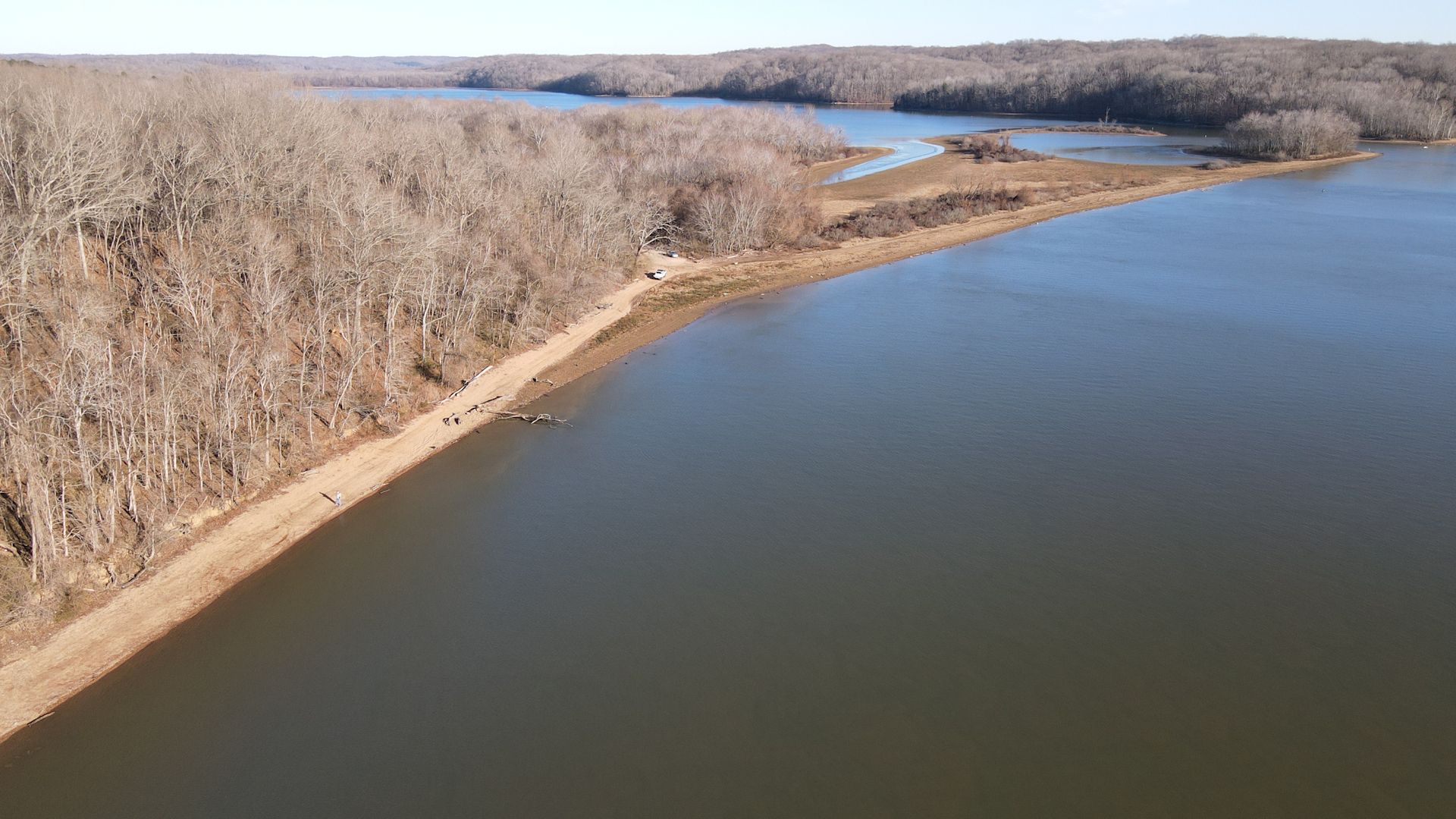
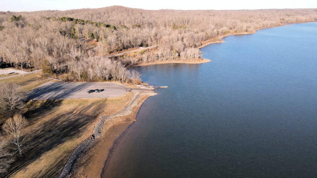
Linton is home to a handful of residents and a couple of churches as well as the Linton Public Day Use Area managed by USACE. The day use area is nice – complete with a large boat ramp, courtesy dock, plenty of parking, a pavilion, restrooms, a playground, and a beach. It once served as a small OHV area, but that has since been prohibited.
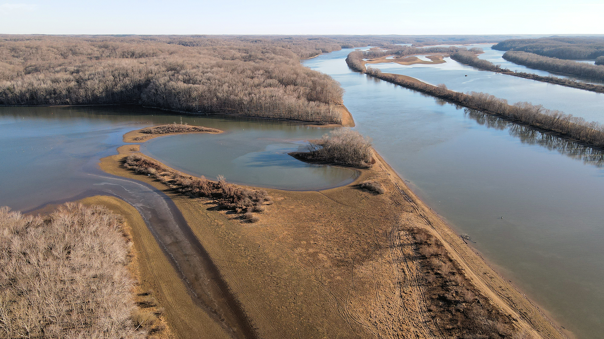
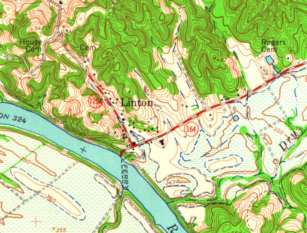
The old junction of Kentucky 164 and Kentucky 1254 (Ferry Landing Road) is now a bit overgrown with trees and brush. The landing area and former site of the town can be accessed when the lake’s elevation is not over summer pool. However, when the lake’s level is high, the old site of Linton is underwater.
When we visited in the winter months, we couldn’t really make out where the old stores and structures once stood. Remains of the roads were clear, but that’s about it.
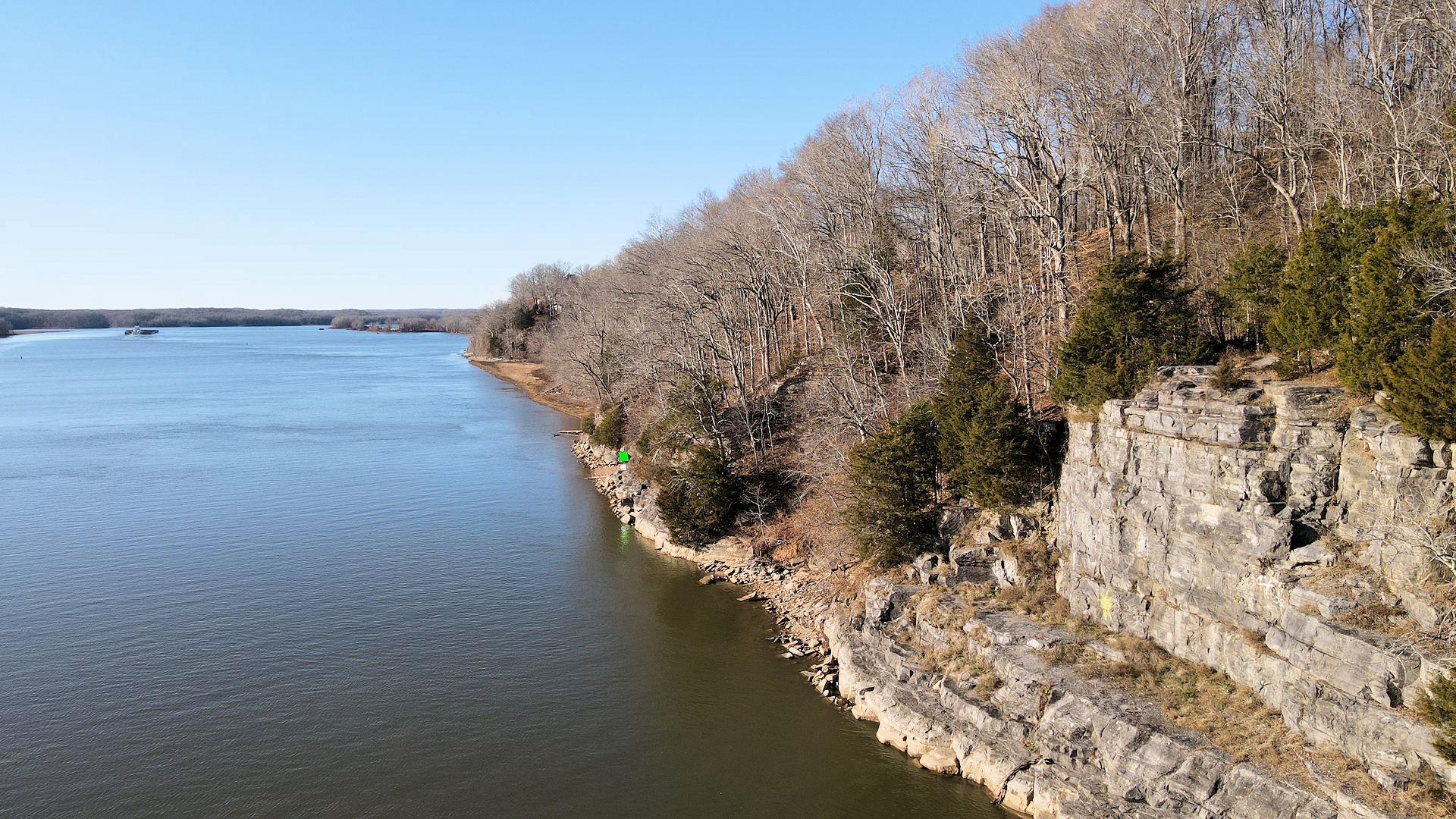
The lake’s level is low in the winter months and one can explore the cliffs along the river at Linton, which climb up over 130 feet. We had read about a small cave located in the bluff that contains a metal ring that allowed ships to tie up back in the day, but we didn’t see the cave and didn’t really look for it. Somewhere along here were the remains of the Stacker Iron Furnace, but again we didn’t find much.
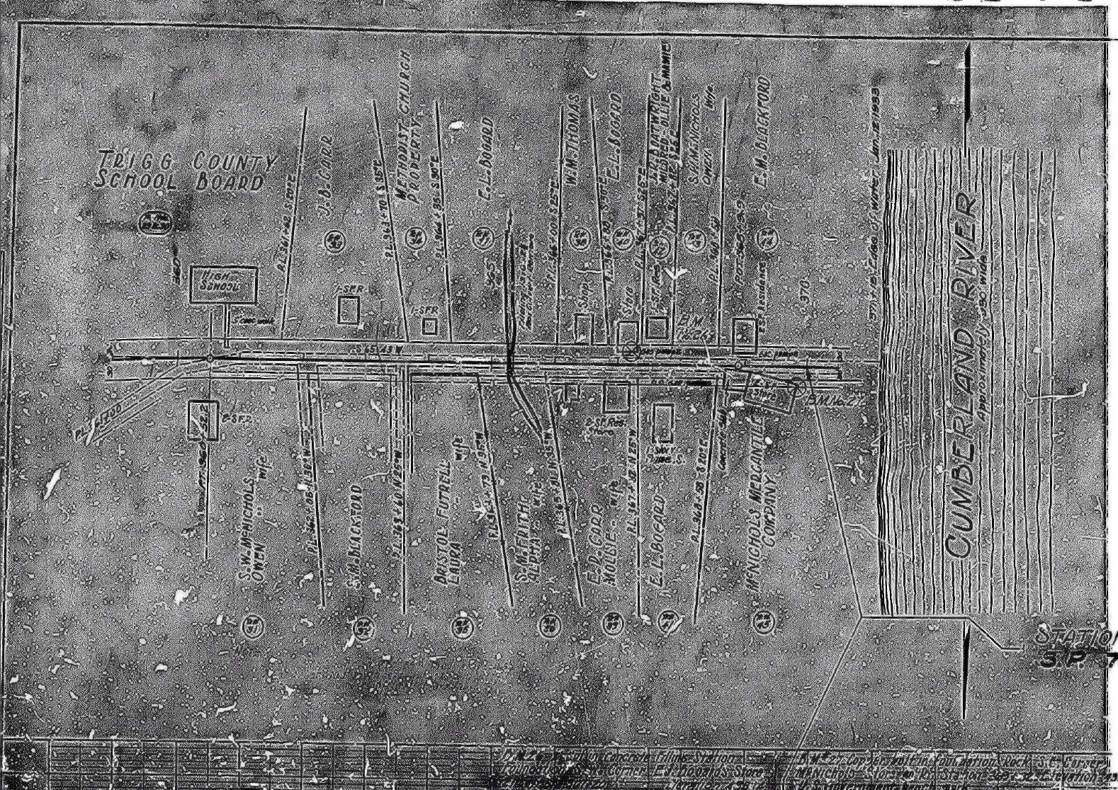
Old Maps of Linton
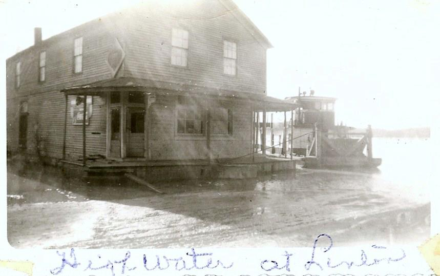
Here you can see what Linton looked like before the creation of Lake Barkley. Some of the images (despite the rough quality) show were businesses were once located when the state built the two roads in the 1930s and 1950s.

Aerial Video of Linton
Check out our drone footage of Linton and the Day Use Area.
Location of Linton
Resources
- Kentucky Transportation Cabinet
- US Army Corps of Engineers
- Trigg County Historical Society
- History of Trigg County – William Henry Perrin (1884)
- Echoes from the Past – Judy Maupin (1979)
- Acts Passed by the Kentucky General Assembly (1861)
- Trigg County Place Names – Robert M. Rennick
Contributions
We would love to hear more about Linton, Kentucky. If you would like to contribute photos or additional historical details, please contact us.
Articles Related to Linton
-
 How Linton, Kentucky Got Its NameDecember 28, 2020/


Pingback: How Linton, Kentucky Got Its Name - Four Rivers Explorer