The present-day US 68/KY 80 corridor has been an important route for more than two centuries. With Canton’s modern history dating back over 200 years (not to mention the prehistoric era), it’s no wonder the main thoroughfare through this part of the county has changed a whopping five times. Evidence of all five generations of this strategic route exists today.
As we covered in a previous article highlighting the history Canton in western Trigg County, this town was an important trading post beginning in the early 1800s. Located on the Cumberland River (today’s Lake Barkley), the town sprung up as a shipping point for areas in southern Kentucky. Goods were transferred by boat at Boyd’s Landing there at the town.
A new road Between Canton and Bowling Green, Ky. was commissioned by the Kentucky State Legislature around 1819-1820. Parts of the road may have used old Native American manways and trails. It has been well documented that Mississippian-era tribes had a settlement at Canton. Even prehistoric artifacts have been found there.
Trade along the route flourished. Lines of freight wagons extending a mile or more were common just about every day. In 1858-59 businessmen from Cadiz and Christian County organized a company to build a turnpike from the landing at Canton to Hopkinsville. A charter for the road was granted and fourteen miles were built from the Cumberland River to Montgomery Village, roughly where Interstate 24 is today. The road cost $60,000.
We aren’t sure if this was a second alignment of the original Columbus & Bowling Green State Road or just another way to go. Because of this unknown, we’ll call this the first generation of the corridor.
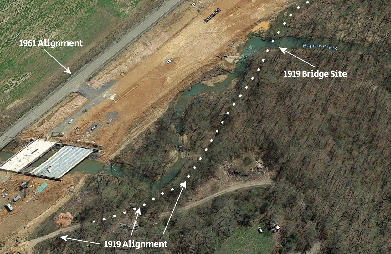
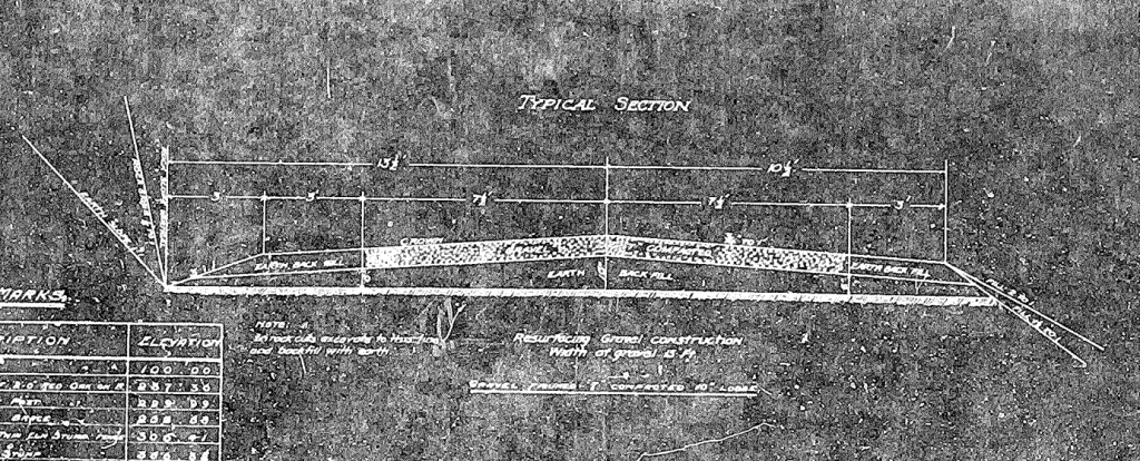
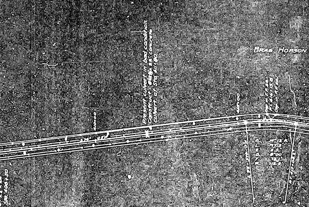
In 1919, the state of Kentucky produced plans to significantly improve the corridor between Cadiz and Canton (called the “Cadiz-Benton Road”). Plans were made to upgrade the existing route with two 7.5-foot lanes that featured compacted gravel. A new bridge over Hopson Creek and new culverts were to be constructed.
No other roads existed like this in this part of the state at the time, demonstrating that the Canton-Cadiz route was quite strategic. The plans called for this new route to run from Little River at Cadiz to Boyd’s Landing at Canton.
While we aren’t sure when construction began, this second-generation route became a reality simply by seeing evidence of it that’s still in existence today. It’s likely the work started that year or in 1920, since stuff tended to get done faster in those days.
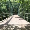
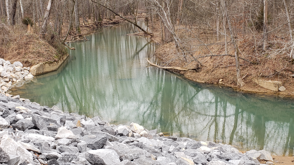
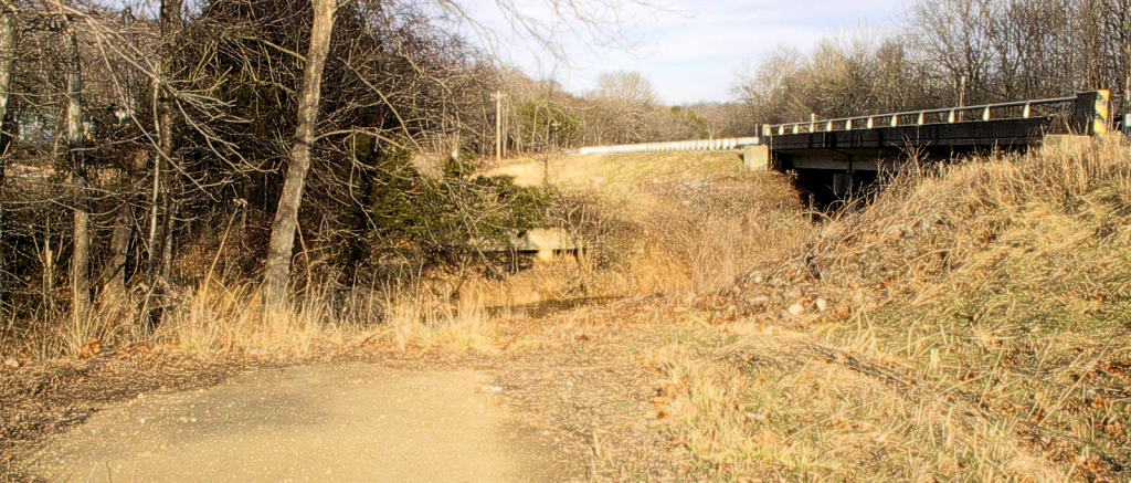
A couple of things that can be seen presently from the 1919 route are the remnants of a bridge that crossed Ramsey Creek (known today at Hopson Creek) very close to the present-day US 68. The creek has spring-fed blue waters and is hard to miss; it bends right up against the new four-lane highway. Right in the bend is an elevated path and old concrete approaches where the bridge once stood.
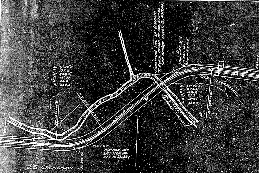
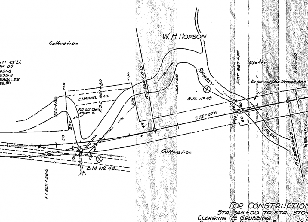
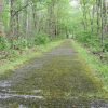
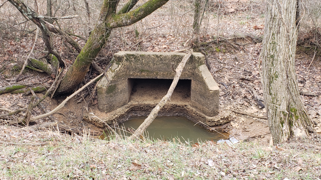
On Old Canton Road (which was the third generation) there is a concrete culvert to the south that is part of the 1919 alignment, which we believe is referenced in the highway plans seen below. Yes, it’s just an old box culvert, but it is likely 100 years old and is left as an artifact of that very first “modern” highway.
The third generation of this corridor came in 1932 with plans to reconstruct the road with wider lanes and actual pavement. It was a needed improvement since the state planned to construct a new bridge across the Cumberland River at Canton. The bridge would replace the ferry at Boyd’s Landing.
Most rural state roads in the early 1930s where gravel at best. With a paved highway running through Trigg County and a large bridge spanning the river, a new link was established that would further strengthen the local economy.
In 1961, the state had to create a couple of new segments of US 68 at Canton and at Cadiz in order to make way for Lake Barkley. The US Army Corps of Engineers began building Barkley Dam downstream, and the rising waters would flood US 68 during high lake level situations.
Thus the fourth generation of US 62 was created in the early 1960s. On the Cadiz end, this meant a new bridge spanning the Little River. On the Canton end, it meant a relocation and elevation change along and near Hopson Creek. The new US 62 featured a concrete surface and wider shoulders for safety.
The photo below, taken in 2001, shows the fourth-generation US 62 on the right and the 1932 version of the highway on the left. Old bridge piers can be seen. The highway on the right had to have an elevation change to cover the potential high-water mark for Lake Barkley.
In the late 1990s the first round of funding was proposed to replace the aging Eggners Ferry Bridge and the Lake Barkley Bridge with four-lane structures. This would mean a new four-lane corridor between Murray and Cadiz, including Canton.
After years of delays and budget issues, construction finally began on the Lake Barkley Bridge project and dirt was being moved to create the fifth-generation US 68 at Canton. Fast forward to today, in 2020, the bridge has been completed and the four-lane highway between Canton and Cadiz is not far from completion.
The fifth generation of US 68 wiped out a lot of interesting features of the old route. Before, one could make out the 1919 version along the north side of the highway quite easily. And an old springhouse on the side of the road was apparently a popular stop in the old days.
Now most of the 1919 alignment and the spring has been obliterated. The comparison photo above showing the 1932 and 1961 alignment has drastically changed as well, with the new road running through it.

Today, the old path down to Boyd’s Landing is still there, although now it’s considered private property. This represents the first generation of the Canton highway. Small parts of the 1919 alignment can been seen and one can still travel down the 1932 alignment (Old Canton Road and the Pete Light Springs area). The 1961 alignment still exists across Little River at Cadiz. The Canton side is gone.
With construction to wrap up later this year, the fifth generation of US 68 will likely serve this area for decades to come.
I’m not aware of a highway in western Kentucky that has been changed five or more times throughout the last hundred years or so. US 68/KY 80 started out as an unnamed path, likely created by Native Americans and filled with wagon ruts. Now it is only the second east-west four-lane highway in western Kentucky, carrying well over a million cars and trucks each year.
Those hard-working men who developed the first modern road in 1919 – I wonder what they would think if they can see what it would look like in 100 years? And to think what this area will look like in 2120? We can only imagine.
Resources
- Kentucky Transportation Cabinet Archives
- Counties of Christian & Trigg, Kentucky – William Henry Perrin – 1884